The Bike View website/app came out of data analysis work at Code for Princeton on New Jersey Department of Transportation Crash Data. In order to use the data further, the Princeton Bike and Pedestrian Alliance member came forward with an idea to use Bike Crash data. Experienced bikers in the Princeton area were able to help out. The user stories are structured around the following questions that users were queried around.
- What kind of App do you want? What feature is most important to the bicyclists?
- As a bicyclist, what problem do you want addressed? What is your main concern?
- What process or program can be made better with technology?
- What do you currently use in terms of an app or a website?
Users can be put into two categories from our sample- all weather bicyclists and those who bike only in warm weather. The ones who bike in all weathers know all the rules and bike on pretty much all lanes- even Rt. 206. Those who bike in warm weather do so on the safe routes that they have explored- which is all roads away from Nassau Street. Following are the user feedback:
- The App would include weather information, updated traffic info, crash info if possible which is in real time for all bicyclists. Some of them would like to know the legal rules of do’s and don’ts for biking around town; safe routes to places would be useful to have. Everyday person who is not an expert bicyclist but wants to bike should be able to get around town safely. Speed limits to be enforced rather than just laid out would help with safe roads for bicyclists. Most people bike during warm weather and some do it despite the cold weather.
- A user operated feature could be a way to report INCIDENTS and not just crashes. People’s rude behavior towards bicyclists, interactions with motorists to be able to report in a comment section- this is more to enable behavior change rather than police reports. The streets have lot of room but there is lack of will to add bike lanes on the streets. If users can add shortcuts on maps so that other users can use them to ride, that would be a nice feature to have.
- The technologies used so far are the following: Strava App, Garmin GPS, Google Maps that provides a safe route for bicyclists. Built-in features that would be good to have are- a voice activated feature activated by location, which can be heard well in the traffic noise would be nice to have- Garmin has it in their GPS for bikes; drop a pin to add something on a map would be good to have (bike racks to share, parking areas to share with other bicyclists’ plan rides with elevation); already set best routes, distance planning, discounts for bike users; a tracker for kids on the map will be great where a parent can see on the map where and how the kid is going on the bike- privacy concerns are to be considered here.
- Condition of the roads is a concern- leaves, brush lying around and not cleaned up is a concern, streetlights are not in good condition; more publicity needed about laws for bikers since these are very unclear; not enough bikers to create a critical mass for support.
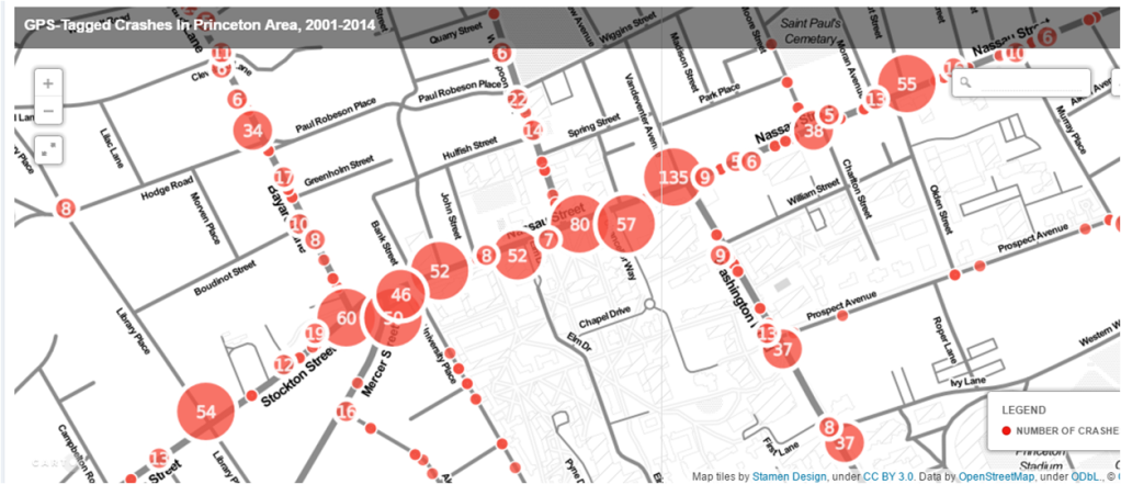
- Map created by Chris Helele and data analytics provided by Jack Kang

Leave a comment